Yazor Brook Flood Alleviation Scheme at CredenhillConstruction Only Award Project Team |
|
The Project
The Yazor Brook flood alleviation scheme has been devised as a strategic measure to help deliver Herefordshire Council’s regeneration plans for the ESG development area in Hereford. Together with other measures within the city and within the development area itself, the previous flood risk has been significantly reduced. Alone it already helps alleviate the flooding in many existing homes and properties directly downstream of the scheme.
The scheme was realised by Herefordshire Council together with its framework partner, Amey, which provided project management. This followed scheme development and planning approval submission by Hereford Futures Ltd (formerly ESG Herefordshire Ltd) on behalf of the Council. The scheme was fully funded by Advantage West Midlands. The Contractor was Dawnus Construction, supported by Mott MacDonald.
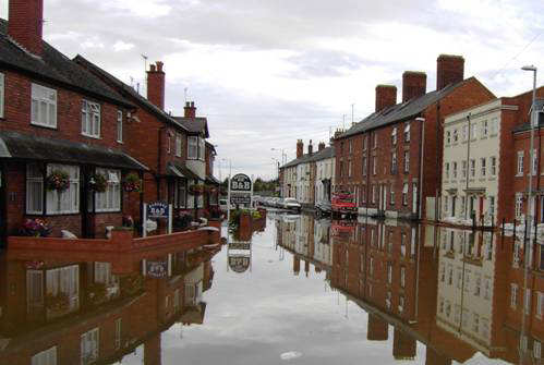
Figure 1 - Newtown Road, Hereford in July 2007. The third day of flooding
Scope of the project
The scope of the works comprised the construction of a reinforced concrete floodwater offtake structure, in the form of a side-weir, alongside the Yazor Brook close to the Credenhill Community Centre, some 5 miles to the north west of Hereford. Water levels are controlled by a downstream flume structure. Diverted water then enters buried plastic pipe (2.0m diameter, 1.3km long) running southward to the edge of the Wye floodplain near Old Weir Farm, located due west of the city, at Swainshill. For the steep descent into the floodplain, a drop of just under 14m over some 70m, water transfers from the pipe into a reinforced concrete chute leading to an energy dissipation chamber at the bottom of the slope. Here the water is churned as a standing wave so that its onward flow into the floodplain field itself is more laminar than otherwise would be the case. The purpose of the dissipation chamber is to help minimise the erosion of the flood plain. From its outfall into the landscaped field, the water is spread to a prepared lip on the edge of the river bank, and from which it will then drop naturally into the Wye, a Special Area of Conservation and a Site of Special Scientific Interest.
Following the exceptionally wet year of 2012, which commenced with the completion of the landscaping works and which led to the scheme being fully operational on a number of occasions, remedial works in the Wye floodplain have become necessary. It is expected that a harder underlying design than that originally constructed will be utilised.
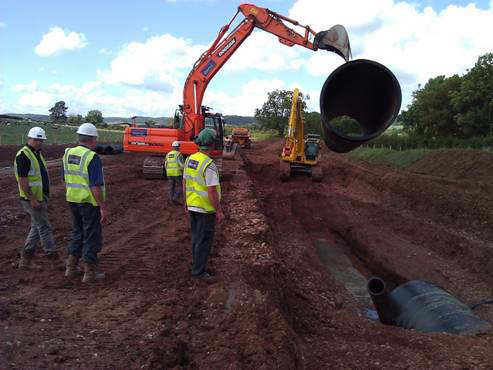
Figure 2. Laying the pipe midway along the alignment
Ecology & Biodiversity
Major restrictions and considerations were focused on environmental matters particularly in terms of ecology, landscape and archaeology. At the offtake at Credenhill, special provision was made for a landscaped fish refuge opposite the side-weir to minimise risk of the fish being swept into the diversion – in keeping with legal requirements of ‘fish friendly’ passages. Within the floodplain, measures have been taken in the landscape design to enable any fish caught up by the diverted flood water to escape into the Wye.
During the weekend closure of the A438 [Hereford to Hay-on-Wye and Brecon] for pipe-laying, the opportunity was taken to install an otter underpass in an area where otter road casualties were prevalent.
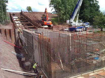
Figure 3. The Energy Dissipation Chamber under construction
Landscape
A significant effort was also placed on minimising impact on the Wye floodplain landscape, undertaken in close co-operation with the National Trust, the landowner. In terms of scheme design, the major challenge was management of the water’s rapid descent into the floodplain. An open stepped channel approach was ruled out predominantly because of high maintenance needs in a wooded environment, access difficulties and landscape intrusion. The alternative approach selected was based on a closed-system used in the USA: the energy dissipation chamber. The novel feature of this structure is that it is completely buried and melds into the original landscape without discernible trace.
To increase the sense of natural flows from the outfall, the floodplain was also sculptured to form a sinuous but widening channel as it approached the river bank.
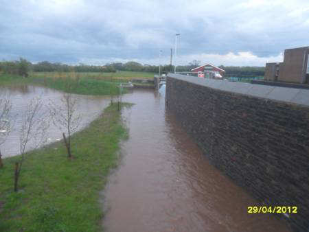
Figure 4. Offtake operational for the first time
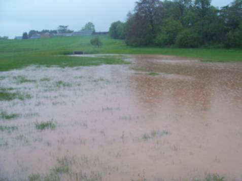
Figure 5. Outfall operational for the first time. A lone tree hides the EDC
Archaeology
The pipe crosses the route of a major Roman road and is close to the former Roman small town of Magnis. Extensive investigation and clearance of the pipe corridor was undertaken with many finds being made by the archaeological contractors from Worcestershire Archive and Archaeology Service. The Roman road was revealed to have been very well constructed with numerous phases of resurfacing and repair indicating a long period of use. To either side of the road, the remains of buildings, fences, ovens, wells, yards and rubbish pits were revealed and substantial quantities of pottery and other artefacts were recovered. These have shown that a busy suburb had developed outside the town walls and extending along this road during the second to third centuries AD. New side streets were discovered, one with evidence of a non-cleared landslip across part of it.
Regeneration
Since becoming operational, the scheme has reduced occurrences of overbanking of the Widemarsh Brook as it flows eastward through the 42.3 Ha brownfield ESG development area just north of the city centre. Widemarsh Brook bifurcates from Yazor Brook shortly after it enters the city.
The development project involves an extension of the city centre out across the current inner road into the now vacated livestock market area to provide new retail and leisure offerings under a partnership arrangement with Stanhope. That £90M scheme is now under construction for completion in spring 2014. The remainder of the development area includes an Urban Village of about 800 residential units, together with the restored Herefordshire and Gloucestershire canal with a new terminal basin, under a partnership arrangement with Sanctuary Group. A planning application for Phase 1 of the Urban Village was submitted in March 2013.
Construction of a new 800m link road running west–east through the northern part of the development area will significantly open up that part of the development area for the urban village scheme, and is expected to commence in 2014. Its secondary function is to significantly reduce the current traffic levels on the inner ring road, by some 50%. That will enable better pedestrian and cycle connectivity across it, a major sustainable travel measure. The inner ring road itself will be remodelled to a fine pedestrian-centric arboreal urban street. Closely associated with the delivery of the Link Road and as a further sustainable travel measure is the inclusion within development plans of an integrated transport hub at Hereford Station.
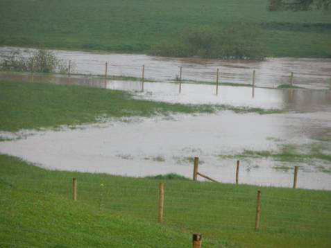
Figure 6. The outfall in to the Wye
Relations with the Local Community & other Stakeholders
Following extensive consultation with the Environment Agency, Natural England, landowners, Hereford Futures Ltd partners and the local communities neighbouring the scheme, planning permission was granted in November 2009. For the city consultation event, a disused shop was modified to simulate a house flooding situation, and was well attended.
Throughout the design and construction process, Dawnus engaged with nearby stakeholders to ensure that they were fully abreast of developments. Community initiatives included a ‘Meet the Contractor’ day held at the local community centre, and the donation and fit-out of new kitchen units for the centre to compensate for any disruption caused. Other community benefits derived from the project included:
- new and modern football changing facilities for the local football club;
- improved car parking facilities;
- improved landscaping adjacent the community hall;
An introduction to the considerate construction industry for the pre-school users located next to the offtake works.
Benefits of CEEQUAL to the project
CEEQUAL helped our project team in a number of ways. It provided a clear framework in which we could benchmark our progress against sustainability aspirations, and ensured that each member of the project team was aware of their responsibilities in achieving CEEQUAL points. Throughout the scheme, workshops to benchmark our progress against these goals meant that sustainability issues were high on the agenda and remained at the forefront of thinking. In turn, the project benefitted from this as further measures such as community focus, waste reduction and water management were incorporated.
The scheme received a CEEQUAL Very Good Award with a score of 72.6%, just 2.4% short of Excellent. We received very high scores in most sections with over 80% awarded for relations with local community and stakeholders, waste management and effects on neighbours and a full 100% for the Water resources and the water environment section. The acknowledged weakness was that initiation of CEEQUAL did not take place immediately on project initiation. So, some actions were not undertaken or recorded because there were not known to be within the CEEQUAL question set and, because CEEQUAL requires evidence to be submitted to gain any question scores, points relating to those early days were not gained.
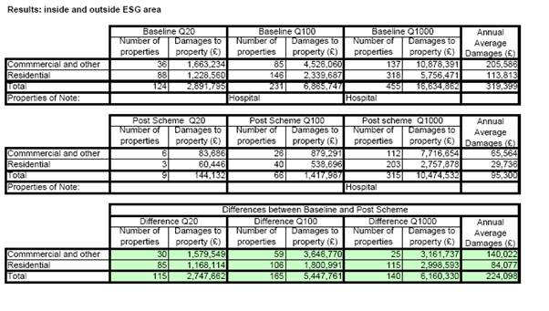
Figure 7. The benefits of the Flood Alleviation Scheme

