White Cart Flood Prevention SchemeHighly Commended CEEQUAL Outstanding Achievement Award 2013 for Landscape Highly Commended CEEQUAL Outstanding Achievement Award 2013 for Community Relations |
(A) Flood Storage Areas: |
Whole Project Awards
Project Team
Client: Glasgow
City Council
Design: Halcrow Group Ltd
Construction: Carillion
(Flood Storage Areas) & VolkerStevin
(Urban Flood Defences)
The Project
The White Cart Water Flood Prevention Scheme is designed to protect
1,750 properties and businesses in the south of Glasgow from the risk
of flooding and over £100 million flood damages. The White Cart
Water is a shallow, fast flowing river which is prone to flash-flooding
and where water levels can rise by 6 metres after only 12 hours of rain.
Since 1908 it has inflicted more than 20 serious floods on homes and
other properties throughout Glasgow’s south side. In January 1984
more than 500 homes were devastated by flooding.
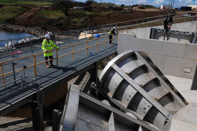
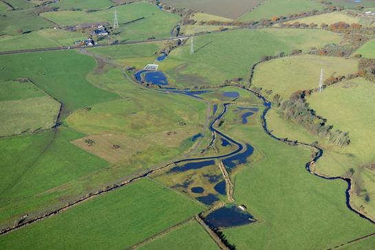
In 2002, the development of a flood alleviation scheme commenced based on a holistic catchment management principle looking for a solution that stretched beyond the city boundaries. The scheme constructed three rural flood storage areas located at at Blackhouse (Earn Water) in East Renfrewshire, Kirkland Bridge (White Cart Water) and Kittoch Bridge (Kittoch Water) in East Renfrewshire and South Lanarkshire. Upstream storage which holds back water during storm events enables downstream urban flood defences along the river to be reduced in height and length. This has significant benefits not only in engineering terms and in the associated visual and environmental impact. High walls would have been undesirable as they would have created a barrier between the river and its wildlife and those that live and work alongside it.
(A) Flood Storage Areas
Initial work focused on identifying potential sites for flood
storage areas in the upper parts of the catchment. Overall, 33 sites
were considered for size, topography and geotechnical suitability to
allow a dam up to fifteen metres in height to be constructed and the
associated environmental impacts. In order to significantly reduce the
lengths and heights of flood defences downstream, it was established
that at least one flood storage area on the White Cart Water and its
two major tributaries the Earn Water and Kittoch Water (minimum of three
in total) would be required upstream to sufficiently constrain the flow
of water. Together the three flood storage areas have the capability
to hold back more than 2.6 million cubic metres of flood water.
Central to the successful operation of the storage areas was the installation of the world’s largest Hydro-Brake flow control devices into the three dams at each storage area. The Hydro-Brake’s internal geometry is designed to enable water to flow unrestricted through it for as long as possible. A self-activating vortex is created when the water upstream reaches a pre-determined height in a flood situation, throttling back the water, and releasing it at a controlled rate. The flow controls have a much larger waterway area when compared to an orifice flow control and this reduces the frequency and duration of flooding at each storage area by allowing higher flows to pass forward at low water depths. This is essential given that most of the land upstream remains in agricultural use. The flow controls offer an efficient fail-safe, passive method of flow control. They do not need power to operate, and once installed, they can be left alone to do their job with minimal maintenance for the foreseeable future.
The flow controls are installed in earth embankment dams constructed at each of the storage areas. Each dam is capable of storing over 0.7 million cubic metres of water, with the largest storing 1.1 million cubic metres, and fall within the requirements of the Reservoirs Act.
Community Involvement
Public consultation was a key aspect of the scheme development
and the selection of the final three flood storage areas. Through one-to-one
discussions and an extensive public exhibition, the views and opinions
of affected parties were obtained and, where possible, incorporated
within the design. The development of engineering designs for the scheme
was complemented by the creation of an environmental working group (EWG).
The group comprised of stakeholders from the Scottish Environment Protection
Agency, Scottish Natural Heritage, Scottish Water, local angling/fisheries
groups and the Royal Society for the Protection of Birds as well as
environmental professionals from the three local authorities. The establishment
of the EWG was a unique approach and an early example of effective collaborative
working.
Wildlife & Biodiversity
As part of the design, plans were made to enhance biodiversity
and wildlife habitat of the area with the creation of woodland, scrub,
and over 90,000 m2 of species-rich wet grasslands, shallow scrapes and
ponds together with various other new habitats.
Waste diversion from landfill
At two out of the three sites the vast majority of material
used to construct the earth dams was won from on-site borrow pits. Earthworks
designs and specifications tailored to suit the material available in
the borrow pits. By using these materials the contractors were able
to reduce the number of lorry movements by 28,000. This significantly
reduced the impacts associated with such a large number of vehicle movements
on the rural road network and reduced the amount of carbon emissions.
At the third site an existing glacial feature was incorporated into
the dam and improved by the installation of 4,500 vibrated stone columns
with the remaining fill being imported from a local source.
Landscape Issues
The alignment of the dams used existing topography where possible
to minimise their height and length. All of the dams have been designed
to overtop floods significantly larger than a 1 in 200 year event and
require concrete channels and blockwork protection to ensure their stability
during these enormous floods. Rather than leave these concrete structures
exposed and potentially unlikely to be used for decades, they were infilled
with sacrificial material and grass cover was established to ensure
the dams blend in with the existing landscape.
(B) Urban Flood Defences
The second element of the project involves the construction
of flood defences downstream in the city. This has involved the design
and construction of 4.5 km of walls in selected reaches of the river
corridor downstream, the raising of two footbridges and the construction
of six surface water pumping stations.
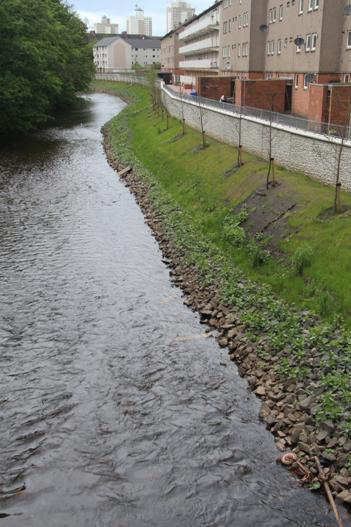
The design philosophy was to ensure all publically accessible parts of the river were not severed by high flood fence walls, which were to have an average height of 0.85 metres. Particular attention was paid to the alignment of the flood defence wall. Where possible, the alignment sought to maximise the retention of the natural flood plain and follow existing boundary walls in order to avoid the reduction in size of private gardens.
Landscape Issues
The presence of numerous underground services, invasive species
such as Japanese Knotweed and Giant Hogweed, the close proximity of
existing buildings and limited access made the design and subsequent
construction of the urban flood defences a significant challenge. The
form of construction adopted considered the constraints and sought to
achieve the most appropriate solution. For example, wall construction
varied from in-situ reinforced concrete, sheet piles installed using
both vibratory and non-vibratory (silent) piling techniques and rotary
bored secant piling.
In many areas the only access to construct the flood defences was from within the river channel. Where this was required, temporary rock haul roads and working platforms were constructed in the river channel and either temporary flood defences put in place or available to be deployed during a flood event. On removal of the haul roads some of the material was recycled and used as scour protection to the toe of the river bank or in some places to form mammal ledges where there had originally been no river bank due to high river training walls.
Community Involvement
In a similar vein to the flood storage areas, significant stakeholder
and public consultation was undertaken to ensure the environmental and
aesthetic impacts of the flood defences were adequately mitigated. The
stakeholder consultation continued through the construction phase with
a full time liaison officer based on site.
A website was established to keep the public informed of the project’s
progress: http://whitecartwaterproject.org and the team also took part
in an active programme of schools support ranging from talks on safety
and the environment through to poster competitions and the provision
of a large planter and tree for the school garden. This was supported
by numerous charitable donations to local community groups including
the provision of new pedal bikes to the local police.
Put to the Test
On 29 November 2011 the scheme passed its toughest test yet
when almost 240 million gallons of water were held back by the scheme
after a months rain fell in a day. Around £11million of damage
is believed to have been averted when flood water was spread over the
naturally contoured storage areas before being released in a controlled
fashion over the following days. Despite the enormous volume of flood
water the incident was comfortably contained within the scheme’s
capacity, with only 43% of the water storage capacity believed to have
been used.
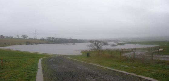
The impounded water at the Kirkland Bridge flood storage area during
significant flood event
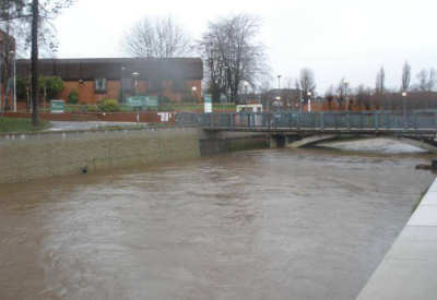
View looking downstream showing flow in due to operation of flood
storage areas
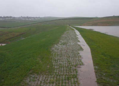
View along dam crest at Kittoch Bridge flood storage bank area during
a significant flood event
Award presentation


