Cross Valley Link Road (CVLR)Highly Commended at Outstanding Achievement Award 2011 for Project Management |

85.9% |
Whole Project Award
Project Team:
Client: Homes
and Communities Agency
Design: Halcrow
Group
Construction: Birse
Civils
 |
|
|
Background
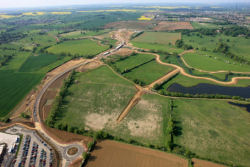
The Cross Valley Link Road (CVLR) south-west of Northampton provides a direct 1.45-km road link connecting the A45 Weedon Road from Daventry to the West and the A45 Upton Way / Danes Camp Way heading to Towcester to the south. It links residential and employment land on either side of the River Nene floodplain and has been delivered in partnership by the Homes and Communities Agency (formerly English Partnerships), Halcrow, Birse, Northamptonshire County Council and the West Northamptonshire Development Corporation (WNDC).
The new road crosses mostly agricultural land in the floodplain of the River Nene. The route bisects an important County Wildlife Site and a Site of Acknowledged Conservation Value, and the immediately surrounding area is designated to become a Country Park, so the environmental and sustainability challenges were significant.
 |
|
|
The Project
The engineering design was for a Category B road with 40mph design speed and 7.3-metre-wide carriageways, incorporating a three-span bridge across the River Nene and two further flood-relief bridges within the floodplain (requiring the minor alignment of a 150-metre length of the River Nene).
Two controlled crossing points were provided that are suitable for pedestrians, cyclists and equestrian users, and the road lighting is of high quality directional type so as to respect the sensitive wildlife of the site and surroundings.
A sustainable drainage system was incorporated to prevent flooding and minimise pollution, whilst extensive landscaping minimises the visual impact of the road embankments.
Key challenges included:
- Managing road alignment to minimise land take, achieve optimum road design, and maximise developable land.
- Developing an appropriate archaeological mitigation strategy to define the nature and ensure the survival of the known and unknown archaeological resources.
- Keeping the vertical alignment of the road as low as possible, within the constraint of having to ensure that the road is higher than the 1-in-1000-years flood level. This, together with a carefully designed horizontal alignment, will reduce the visual impact of the road and its embankment in the Nene Valley.
- Preparing a landscaping strategy that responds to wildlife interest and environmental constraints of topography and the landscape character of the River Nene corridor, whilst also conserving and enhancing existing features such as hedgerows and significant mature trees, and minimising the loss of vegetation due to construction.
Ecology
Strategies were developed for the management of ecological resources and to minimise effects of the construction work on populations of badgers, bats, otters and birds.
Mitigation strategies were designed not only for the impact of the road scheme, but also for the potential cumulative effects of the urban development in the South West District.
Mitigation measures undertaken included:
- Translocation of marginal vegetation during realignment of the River Nene, and of valuable grassland habitat and an ancient hedgerow
- Creation of log piles for refuge for reptiles and amphibians
- Environmental protection and ecological mitigation measures for reptiles, water voles, fish, river mussels, birds, bats and badgers
- Localised modifications to highway verge and flood bund to avoid damage and loss of mature oak trees
- Creation of water-meadow and hay-meadow habitats, using some seed harvested from local nature reserves.
An Ecological Clerk of Works was on site throughout construction using an ‘Ecological Permit to Work’ licensing process.
As a result of these measures, the project can boast the following statistics:
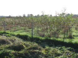
- 25,000 native trees and shrubs planted
- 20 ha wetland habitat created
- 1,000 willow cuttings grown in on-site willow nursery
- 900 kg wildflower seed sown, including some locally harvested
- 392 m species-rich hedgerow translocated.
 |
|
|
Waste & Environment
Sediment control measures and on-site storage lagoons were use to control silt and provide greywater.
All topsoil stripped and subsoil excavated was reused on site and, by importing fill material from a neighbouring site, some 14,000 lorry movements were kept off the public road network.
Road stone was transported to Northampton railhead before local delivery to site.
Community involvement
Stakeholder requirements and public and expectations were managed through a series of meetings, workshops and exhibitions to establish the key issues and constraints, and to determine the best solutions for mitigation.
Extensive community consultation was carried out during planning, design and construction, including presentations to the Parish Council and quarterly newsletters distributed locally.
In addition, local groups and charities were supported through sponsorship and joint participation in the Kislingbury Village Fayre as well as through the CVLR Charity Fun Run” organised on the new road with a local running club. A total of £20,000 were raised for local charities through project activities.
