Dartford Creek |

84.6% |
Whole Project Award
Project Team:
Client: Environment
Agency
Designer: Ove
Arup & Partners
Contractor: Team
Van Oord
The Project
Dartford Creek is one of the last remaining natural tidal creeks in London. The flood embankments along Dartford Creek provide 1:1000 year flood protection to 620 residential and commercial properties. Over time, the stability of these embankments had been undermined by natural migration of the river channel, where erosion and over-steepening of the banks caused geotechnical slip failures. The flood embankments had suffered multiple failures in recent years, urgently requiring a permanent solution.
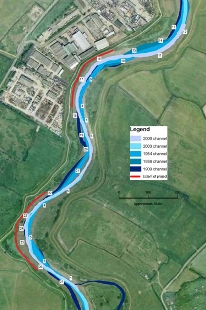
The £5m Grant-in-Aid scheme, designed by Arup and constructed by Team Van Oord for the Environment Agency, returned the channel to its historical position and provides long-term erosion protection to the flood embankments. The integrated team approach ensured completion ahead of programme and within the target cost.
 |
|
Use of Brushwood Faggots
The Environment Agency required a soft-engineered solution using sustainable techniques to restore flood defence robustness, integrity and create salt marsh habitat. Although brushwood faggots have been used for centuries in riverbank reinforcement, this modern use is innovative both in terms of scale and interaction with the natural processes of scour and siltation.
 |
|
Design
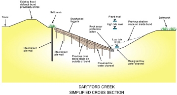
The design solution was to re-profile the alluvial slopes to establish a flatter, stable slope, protecting the slope toe from erosion and combating deep-seated rotational slip failures in the flood embankments.
The sustainably sourced brushwood faggots, held in place by timber stakes, formed a matrix which reduced water velocity and encouraged silt accumulation on the foreshore. The brushwood was carefully profiled to create a naturalistic river meander. Rock rolls (circular gabion baskets) were used to protect the brushwood toe. This protection from undermining and erosion was critical to the design.
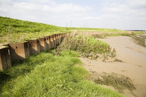
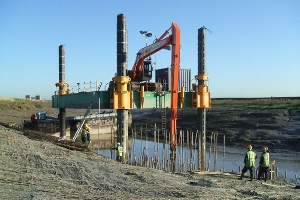
Steel sheet piles were placed along the toe of the flood embankments to provide a secondary defence line and to resist deep geotechnical slip failures. This technique was verified through the application of thorough geotechnical design principles, producing a sustainable engineering solution and enhancing the local ecology while protecting the Biological Action Plan (BAP) habitat.
 |
|
Monitoring Programme
One of the Environment Agency’s main concerns was whether steepening the opposite foreshore would lead to large scale slips and loss of salt marsh. A five year monitoring regime implemented during construction allows early intervention should any adverse impacts from the remedial works become apparent.
LIDAR surveys of this inaccessible area coincident with vegetation surveys provided detailed monitoring of changes in foreshore level and ecological condition and function. Findings show that the creek responded broadly as predicted. There is no evidence of adverse impacts on the opposite salt marsh or flood embankments.
 |
|
